You are allowed three cities per plot, not per district. I referenced this post of yours.
The rest will be edited after the Activity Check is over.
then how does Besern have 18 over 3 plots?
The city restriction rule did not exist from the start, which means there are several nations that were added before the rule. That is why some plots have so many stuff in them
oh ok
The following nations were removed due to failing the activity check:
Following nations have not reacted to the activity check as expected, but a decision in their favour was made (reason in parenthesis):
Following nations were removed upon player request:
- Ateemara
- Katriini
- Thalapadis
Apart from removing Cambridge I was not able to process your edit request in any way, because the mentioned cities and rivers are not on the map and thus can’t be removed. Ipswich cannot be added due to your plot already exceeding the limit of visible cities.
Done!
You can now apply for additions or edits on the map again.
I’d like for Olkanga to be renamed to “Kalaki Autonomous Duchy of Olasta” and have the text size be the same as Mira (Okhoa Protectorate)
Link to NationStates nation in the South Pacific: Nalau
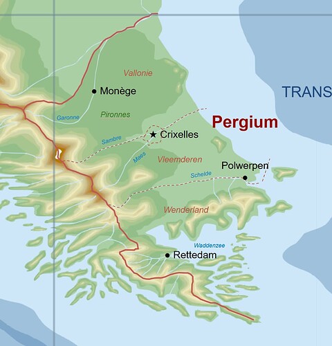
Name for your plot: Pergium
Desired plot: 042
Capital: CRIXELLES
Location of capital: See customization
Customisation:
Already owned plot(s)*: Pekelau
I confirm that I have:
read the instructions
the intent to participate in roleplay in the Pacifica canon
made sure that the plot hasn’t been claimed by someone else
given each plot I claim a separate name
Apart from removing Cambridge I was not able to process your edit request in any way, because the mentioned cities and rivers are not on the map and thus can’t be removed. Ipswich cannot be added due to your plot already exceeding the limit of visible cities.
I meant from the edit request because I’ve moved all the cities around a bit. Ignore what’s actually on the map rn. Also what’s the limit of visible cities?
Per plot four cities (usually capital + three cities)

Just do London, Birmingham, Nicholasgrad, Lokve, Glasgow, Leeds, Manchester and Durness
Sorry for bugging you for the third time but I have made another change to my plot.
- Rename the thing
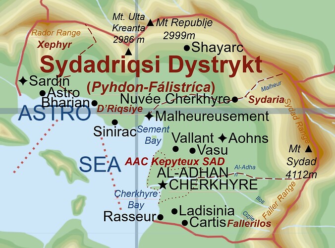
Sydadriqsi Dystrykt (Pyhdon-Fálistríca) - Rename “Mal Sharon”
D'Riqsiye, making “✦Malheureuesement” a state capital using this symbol✦. If this makes me eligible for another city addSinirac - Cut Mal Sharon with a line in the shape of a backward S and name this
Xephyr. Make “✦Sardin” the State Capital using this symbol✦. If that makes me eligible for another city, addBharianas another city - Rename “
Kepytohns”Sydaria, adding “✦Aohns” as the State Capital using this symbol✦. If eligible for another city, add “Nuvée Cherkhyre” as a city. - Going along the Al-Adhan River, add a line through and call this district
Fallerios.AAL-ADHAN CHERKHYRE(respell) would be the capital of this but as it is the capital of the entirty of the Dystrykt it would stay with a 5-pointed star. Please move it closer to the coast and branch River Aal-Adhan (respell) where you put it, creating an island - Change
Mt Ulta Kreanta’s height to2986, and addMt Republįeat2999height next to it - Add
Mt Sydadat4112height near the headwater of the Aal-Adhan River - Have a good day, get yourself something you like, and chillax for the rest of the day. You earned it.
The reason i ask is to just make the plot get a sense that it is a really overpopulated plot with a lot of cities like Besern
For reference and Copy-Paste (if needed) refer to this slideshow’s first page where the Sydadriqsi Dystrykt is shown (click on it).
Thank you,
riditekhstudios/Pyhdon-Fálistríca
I wonder if the state capital can get a custom sign
And also they won’t make you able to add another city, it is just a capital and three cities per plot.
also, your map editing looks quite good
thanks! for advice and compliment! I just used Fargentino’s advice!
I’m trying to see how hard it is to map edit like Gianni so that i can become a map editor (not mod, editor)
Link to NationStates nation in the South Pacific: NationStates | The Dynastic Roman Empire of Aurorastan
Name for your plot: (The name of your country that you want to see on the map, which may be different from your NationStates nation name. Please keep it short.)Saleniotaro
160: (Please make sure the plot hasn’t been claimed by checking the last few pages this thread.)
Capital: SALENTARA
Caputal Location: Nea the Helezegoky Plain
Customisation: (An image as illustration is always appreciated, accompanied by a list that allows copy/paste)

SALENTARA
SUMATA
SALAJUNA
Already owned plot(s)*: (List the the name(s) of the plot(s) that you have been granted on the map, in any)
I confirm that I have:
read the instructions
the intent to participate in roleplay in the Pacifica canon
made sure that the plot hasn’t been claimed by someone else
given each plot I claim a separate name
Sorry, there is no image provided. Edit your post to have an image so that the editors know how to customize your map.
How can i make he image? (I made it with gallery bruh)
Either use imgur or upload from a file, I can’t see the image on my side (either you didn’t sucessfully upload it or it’s just my device)
I used ibb to upload the image
Ah, ok
Link to NationStates nation in the South Pacific: NationStates | The Federation of New Chinese Federation & NationStates | The Mountainous Flat Country of 7 Trees
Name for your plot: Litradi (Officially The Kuitru of Litradi)
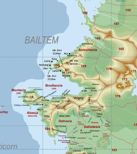
Desired plot: 168
Capital: TRITURA
Location of capital: Below
Customisation:
Ignore the circle cities since I can only have 3. Only add the square ones. ALL CAPS is capital.
Cities by Pop (Italics indicates square city, caps indicates the capital) (All 7 are governing cities.):
- TRITURA (120,340)
- Lutra (72,210)
- Loturi (51,192)
- Atri (39,676)
- Haldro (10,201)
- Trita (10,001)
- Absi (9,801)
And Mountains:
Mt. Loru (4532m)
Mt. Hal (4023m)
Mt. Otri (3329m)
Mt. Sitri (3104m)
Already owned plot(s)*: None
I confirm that I have:
read the instructions
the intent to participate in roleplay in the Pacifica canon
made sure that the plot hasn’t been claimed by someone else
given each plot I claim a separate name
(Mark with X)


